Freezing Weather Notification

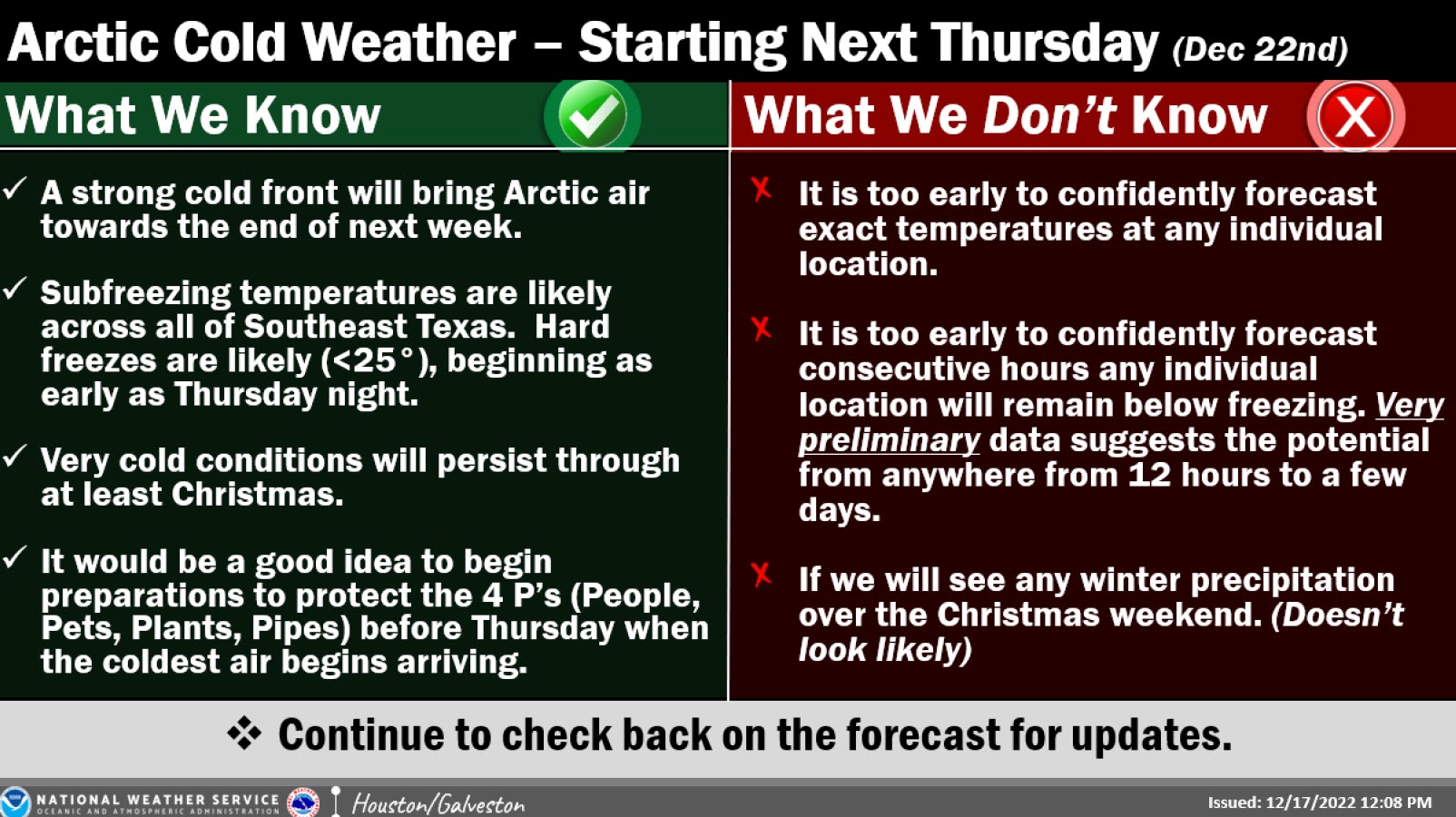
Winter weather and freezing temperatures are expected this week across Texas. The National Weather Service is forecasting widespread freezing temperatures on Friday and Saturday morning (12/23 – 12/24). In such conditions, it is imperative to protect the “Four P’s”: People, pets, pipes and plants.

People

  • Keep warm, stay inside if possible.
  • If you need to go out, dress in layers and wear hats, gloves and an appropriate coat.
  • Avoid overexertion, as cold weather puts added strain on your body.

Pets

  • Bring pets inside, and move other animals or livestock to sheltered areas.
  • Keep adequate food and water available.

Pipes

  • Disconnect outdoor hoses, drain and store in protected area.
  • Wrap exposed faucets and pipes – including those outside the house or in unheated crawl spaces, attics, garages and other areas.

Plants

  • Bring potted plants inside or store in garage near interior wall to provide extra warmth and protection from wind.
  • For cold-sensitive outdoor plants, put down extra mulch and consider covering with a cloth fabric of some kind to shield the plants from wind and frost.

Additionally, if you have an irrigation system, turn off the water to the system at your backflow preventer and then drain the system so your irrigation pipes and sprinkler heads are not damaged.

As it pertains to the dripping of faucets, we are asking and advising our residents and customers NOT to drip their faucets. This could cause a dip in water pressure at your facility. If you reside within the greater Houston area and are part of the Regional Water Authorities (West Harris County Regional Water Authority, North Fort Bend Regional Water Authority, North Harris County Regional Water Authority), or receive water from the City of Houston, dripping faucets will put a strain on the system resulting in low pressure or even depleting the water system.

The following sites can also be used as a source of information and to keep you updated:


Weather Update as of 12/19/22

  • The approaching arctic air outbreak will be the coldest air mass since February 2021.
  • It is forecast that temperatures will drop quickly Thursday Night into Friday Morning.
    • Temperatures likely to be in the teens north of Highway 105, near 20 degrees near I-10, and in the mid 20s south of I-10
    • Many areas could be below freezing for 20-36 hours
  • Many areas will likely not get above freezing on Friday.
  • Though warming into the upper 30s will occur on Saturday, temperatures will drop below freezing on Saturday Night/Sunday Morning

Important to Protect the Four Ps

  • People
  • Pets
  • Plants
  • Pipes

National Weather Service Information

  • Thursday into the Christmas Holiday
    • The Arctic front is on track to move into the area on Thursday. It will bring periods of freezing temperatures (and likely some <25°) into much of the weekend.
    • Too early to confidently pinpoint exactly just how low readings will fall, or how many consecutive hours below freezing any single location will get.
    • Confidence is high that we will see some bitterly cold air and freezing temperatures, but don’t focus on any individual model, or model run, this far out.
    • The specifics will change as time progresses.
  • All businesses and residents should begin preparation for some hard freezes before the coldest weather is set to move in on Thursday.
  • For industry that needs an extended amount of lead time, the NWS encourages individuals to review plans/actions that might need to be implemented should conditions warrant (any extended durations of subfreezing temperatures, gale force winds, high seas, low water conditions, etc.)

Notice Regarding Extreme Weather Emergencies

This communication is to notify you that Cinco Municipal Utility District No. 8, your retail water and sanitary sewer provider is:

  • prohibited from imposing late fees or disconnecting retail water or sewer service for nonpayment of bills that are due during an extreme weather emergency until after the emergency is over;
  • required to offer a payment schedule to a customer who requests such a schedule for unpaid bills due during an extreme weather emergency; and
  • prohibited from disconnecting retail water or sewer service for nonpayment of bills due during an extreme weather emergency until after a payment schedule has been offered and the customer has either declined to accept the payment schedule in a timely fashion or violated the terms of the payment schedule.

For purposes of this communication, an “extreme weather emergency” is defined as a period beginning when the previous day’s highest temperature in an area did not exceed 28 degrees Fahrenheit and the temperature is predicted to remain at or below that level for the next 24 hours according to the nearest National Weather Service reports for that area. An extreme weather emergency is over on the second business day the temperature exceeds 28 degrees Fahrenheit.

Aviso Sobre Emergencias Climáticas Extremas

Esta comunicación es para notificarle que su proveedor de agua y alcantarillado sanitario Cinco Municipal Utility District No. 8 es:

  • prohibido imponer cargos por demora o desconectar el servicio de agua o alcantarillado por falta de pago de las facturas que vencen durante una emergencia climática extrema hasta después de que termine la emergencia;
  • obligado a ofrecer un plan de pago a un cliente que solicite dicho acuerdo para las facturas adeudadas durante una emergencia climática extrema; y
  • prohibido desconectar el servicio de agua o alcantarillado por falta de pago de facturas adeudadas durante una emergencia climática extrema hasta que se haya ofrecido un plan de pago y el cliente se haya negado a aceptar el plan de pago de manera oportuna o haya violado los términos del plan de pago.

A los fines de este comunicado, una “emergencia climática extrema” se define como un período que comienza cuando la temperatura más alta del día anterior en un área no superó los 28 grados Fahrenheit y se pronostica que la temperatura permanecerá en ese nivel o por debajo de este durante las próximas 24 horas. de acuerdo con los informes del Servicio Meteorológico Nacional más cercano para esa área. Una emergencia climática extrema termina el segundo día hábil en que la temperatura supera los 28 grados Fahrenheit.